
Soft Infrastructure in the Urban Estuary / Palisade Bay
|
|
|||||||||||
Bibliografische Angaben
| Autor(en): |
Guy J. P. Nordenson
Catherine Seavitt Adam Yarinsky Michael W. Tantala |
||||
|---|---|---|---|---|---|
| Medium: | Tagungsbeitrag | ||||
| Sprache(n): | Englisch | ||||
| Tagung: | IABSE Symposium: Large Structures and Infrastructures for Environmentally Constrained and Urbanised Areas, Venice, Italy, 22-24 September 2010 | ||||
| Veröffentlicht in: | IABSE Symposium Venice 2010 | ||||
|
|||||
| Seite(n): | 158-159 | ||||
| Anzahl der Seiten (im PDF): | 8 | ||||
| Jahr: | 2010 | ||||
| DOI: | 10.2749/222137810796023953 | ||||
| Abstrakt: |
The movement of water along a vertical scale draws attention to the subtle realities of topography and the consequential horizontal extent of flooding. During a flood, the section gives rise to new configurations and understandings of the city. Today, flooding has become synonymous with the impact of global sea level rise, and the threat of rising waters has taken on a new sense of urgency. Studying the planar transformation that takes place during a time of high water is an opportunity to reinvent and redesign the 21st-century city, and to consider new notions of urban and ecological development. We are particularly interested in questioning both the notion and the effectiveness of “hard infrastructure,” exemplified by seawalls and storm surge barriers. These reduce the zone of floodwater absorption to a singular line in plan and a singular wall in section. We propose the development of a new strategic approach toward flooding that we call “soft infrastructure”— multiple and iterative strategies that buffer or absorb flooding. These strategies operate at the merged surface of the land’s topography and the water’s bathymetry, or in the shallow flats below the water. We envision the water’s edge as a fluid and temporal limit between the water and the land. Our analyses include computational hydrodynamic and hazard models to predict flooding and their consequences in the New York and New Jersey harbor region. |
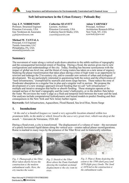
||||